Thank you for supporting this site ❤️
Make a donation
Make a donation
Gear up for your next adventure:
As an Amazon Associate, this site earns from qualifying purchases at no extra cost to you.
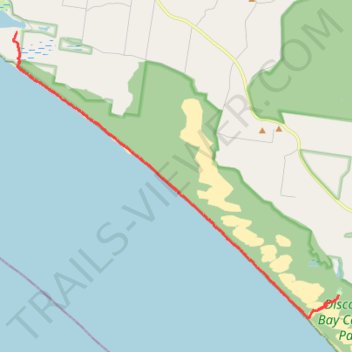
Great Southern West Walk - Monibeong to Swan Lake
- Distance: 16.8 Km
- Elevation gain: 66 m
- Maximum elevation: 21 m
- Elevation loss: 66 m
- Minimum elevation: -1 m
- Moving time: 4 h 17 m
- Moving speed: 3.9 Km/h
- Maximum speed: 8.6 Km/h
- Total time: 4 h 30 m
- Global speed: 3.7 Km/h
Interactive trail map
Thank you for supporting this site ❤️
Make a donation
Make a donation
Gear up for your next adventure:
As an Amazon Associate, this site earns from qualifying purchases at no extra cost to you.
Trail profile
- Distance: 16.8 Km
- Elevation gain: 66 m
- Maximum elevation: 21 m
- Elevation loss: 66 m
- Minimum elevation: -1 m
- Moving time: 4 h 17 m
- Moving speed: 3.9 Km/h
- Maximum speed: 8.6 Km/h
- Total time: 4 h 30 m
- Global speed: 3.7 Km/h
Thank you for supporting this site ❤️
Make a donation
Make a donation
Gear up for your next adventure:
As an Amazon Associate, this site earns from qualifying purchases at no extra cost to you.
About this trail
Name: Great Southern West Walk - Monibeong to Swan Lake trail, distance, elevation, map, profile, GPS track
End: Swan Lake Road, Mount Richmond, Shire of Glenelg, Victoria, 3305, Australia (-38.21630 141.31095)
Coordinates: -38.22336 141.18283 -38.13508 141.31096
Topography: Victoria topographic map, elevation, terrain
Thank you for supporting this site ❤️
Make a donation
Make a donation
Gear up for your next adventure:
⌚Altimeter Barometer Watches - Outdoor watches with built-in sensors to track altitude changes and weather shifts
As an Amazon Associate, this site earns from qualifying purchases at no extra cost to you.