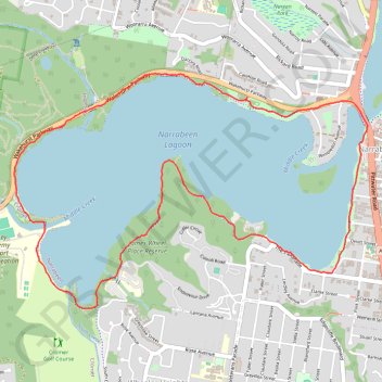
Narrabeen Lagoon Loop
Bilarong Reserve. James Wheel Place Reserve. Middle Creek Reserve. #Hiking #Loop #Bilarong #JamesWheel #MiddleCreek
- Distance: 8.6 Km
- Elevation gain: 89 m
- Maximum elevation: 14 m
- Elevation loss: 89 m
- Minimum elevation: -1 m
- Moving time: 1 h 36 m
- Moving speed: 5.4 Km/h
- Maximum speed: 9.5 Km/h
- Total time: 1 h 36 m
- Global speed: 5.4 Km/h
Interactive trail map
Trail profile
- Distance: 8.6 Km
- Elevation gain: 89 m
- Maximum elevation: 14 m
- Elevation loss: 89 m
- Minimum elevation: -1 m
- Moving time: 1 h 36 m
- Moving speed: 5.4 Km/h
- Maximum speed: 9.5 Km/h
- Total time: 1 h 36 m
- Global speed: 5.4 Km/h
About this trail
Name: Narrabeen Lagoon Loop trail, distance, elevation, map, profile, GPS track
Coordinates: -33.72394 151.26954 -33.70871 151.29700
Topography: Sydney topographic map, elevation, terrain
Other hiking, mountain biking, running and outdoor activity trails
Click on a trail to view its statistics, map and profile.
Narrabeen Lagoon, Elanora Heights and Caleyi Trail loop
Australia > New South Wales > Sydney
Distance: 13.2 Km • Elevation gain: 301 m • Maximum elevation: 198 m