Thank you for supporting this site ❤️
Make a donation
Make a donation
Gear up for your next adventure:
As an Amazon Associate, this site earns from qualifying purchases at no extra cost to you.
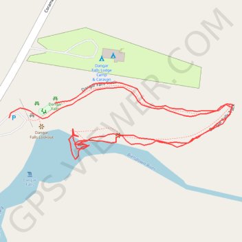
Dangar Falls - Bielsdown River
- Distance: 1.3 Km
- Elevation gain: 20 m
- Maximum elevation: 699 m
- Elevation loss: 17 m
- Minimum elevation: 681 m
- Moving time: 18 m
- Moving speed: 4.2 Km/h
- Maximum speed: 6.4 Km/h
- Total time: 23 m 4 s
- Global speed: 3.3 Km/h
Interactive trail map
Thank you for supporting this site ❤️
Make a donation
Make a donation
Gear up for your next adventure:
As an Amazon Associate, this site earns from qualifying purchases at no extra cost to you.
Trail profile
- Distance: 1.3 Km
- Elevation gain: 20 m
- Maximum elevation: 699 m
- Elevation loss: 17 m
- Minimum elevation: 681 m
- Moving time: 18 m
- Moving speed: 4.2 Km/h
- Maximum speed: 6.4 Km/h
- Total time: 23 m 4 s
- Global speed: 3.3 Km/h
Thank you for supporting this site ❤️
Make a donation
Make a donation
Gear up for your next adventure:
As an Amazon Associate, this site earns from qualifying purchases at no extra cost to you.
About this trail
Name: Dangar Falls - Bielsdown River trail, distance, elevation, map, profile, GPS track
Coordinates: -30.32308 152.71398 -30.32215 152.71711
Topography: New South Wales topographic map, elevation, terrain
Thank you for supporting this site ❤️
Make a donation
Make a donation
Gear up for your next adventure:
As an Amazon Associate, this site earns from qualifying purchases at no extra cost to you.