Make a donation
Gear up for your next adventure:
As an Amazon Associate, this site earns from qualifying purchases at no extra cost to you.
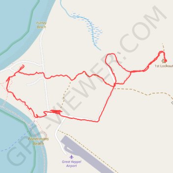
Mount Wyndham - Lighthouse
Great Keppel Island. #Hiking #Loop #GreatKeppel
- Distance: 4.0 Km
- Elevation gain: 62 m
- Maximum elevation: 59 m
- Elevation loss: 62 m
- Minimum elevation: 3 m
- Moving time: 1 h 5 m
- Moving speed: 3.7 Km/h
- Maximum speed: 33.6 Km/h
- Total time: 1 h 9 m
- Global speed: 3.5 Km/h
Interactive trail map
Make a donation
Gear up for your next adventure:
As an Amazon Associate, this site earns from qualifying purchases at no extra cost to you.
Trail profile
- Distance: 4.0 Km
- Elevation gain: 62 m
- Maximum elevation: 59 m
- Elevation loss: 62 m
- Minimum elevation: 3 m
- Moving time: 1 h 5 m
- Moving speed: 3.7 Km/h
- Maximum speed: 33.6 Km/h
- Total time: 1 h 9 m
- Global speed: 3.5 Km/h
Make a donation
Gear up for your next adventure:
As an Amazon Associate, this site earns from qualifying purchases at no extra cost to you.
About this trail
Name: Mount Wyndham - Lighthouse trail, distance, elevation, map, profile, GPS track
Start: The Keppels, Livingstone Shire, Queensland, Australia (-23.17772 150.93542)
End: The Keppels, Livingstone Shire, Queensland, Australia (-23.17781 150.93541)
Coordinates: -23.18103 150.93439 -23.17692 150.94454
Topography: Queensland topographic map, elevation, terrain
Make a donation
Gear up for your next adventure:
As an Amazon Associate, this site earns from qualifying purchases at no extra cost to you.