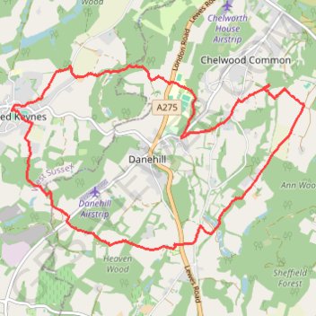
Walk - Horsted Keynes, Danehill, Heaven Farm
- Distance: 13.1 Km
- Elevation gain: 282 m
- Maximum elevation: 125 m
- Elevation loss: 282 m
- Minimum elevation: 44 m
- Moving time: 2 h 49 m
- Moving speed: 4.6 Km/h
- Maximum speed: 7.1 Km/h
- Total time: 3 h 29 m
- Global speed: 3.7 Km/h
Interactive trail map
Trail profile
- Distance: 13.1 Km
- Elevation gain: 282 m
- Maximum elevation: 125 m
- Elevation loss: 282 m
- Minimum elevation: 44 m
- Moving time: 2 h 49 m
- Moving speed: 4.6 Km/h
- Maximum speed: 7.1 Km/h
- Total time: 3 h 29 m
- Global speed: 3.7 Km/h
About this trail
Name: Walk - Horsted Keynes, Danehill, Heaven Farm trail, distance, elevation, map, profile, GPS track
Coordinates: 51.01924 -0.02786 51.04154 0.02864
Other hiking, mountain biking, running and outdoor activity trails
Click on a trail to view its statistics, map and profile.
Walk - Danehill, Chelwood Gate, Birchgrove, Horsted Keynes
United Kingdom > England > East Sussex > Wealden > Danehill
Danehill, Chelwood Gate, Birchgrove, Horsted Keynes
Distance: 15.9 Km • Elevation gain: 344 m • Maximum elevation: 157 m
Walk - Danehill, Horsted Keynes
United Kingdom > England > East Sussex > Wealden > Danehill
Distance: 12.5 Km • Elevation gain: 227 m • Maximum elevation: 118 m
Walk - Scaynes Hill, Horsted Keynes, Lindfield
United Kingdom > England > West Sussex > Mid Sussex > Scaynes Hill
Distance: 16.8 Km • Elevation gain: 224 m • Maximum elevation: 86 m
Loop Walk between Scaynes Hill and Horsted Keynes
United Kingdom > England > West Sussex > Mid Sussex > Scaynes Hill
Distance: 18.2 Km • Elevation gain: 256 m • Maximum elevation: 100 m
Loop Walk - Danehill, Chelwood Gate, Birchgrove, Horsted Keynes
United Kingdom > England > East Sussex > Wealden > Danehill
Distance: 17.8 Km • Elevation gain: 377 m • Maximum elevation: 157 m
Walk between Scaynes Hill and Horsted Keynes
United Kingdom > England > West Sussex > Mid Sussex > Scaynes Hill
Distance: 15.8 Km • Elevation gain: 252 m • Maximum elevation: 93 m
Walk - Ardingly, West Hoathly, Horsted Keynes
United Kingdom > England > West Sussex > Mid Sussex > Ardingly
Distance: 18.9 Km • Elevation gain: 408 m • Maximum elevation: 182 m
Walk - Ardingly Reservoir, Horsted Keynes
United Kingdom > England > West Sussex > Mid Sussex > Ardingly
Distance: 10.7 Km • Elevation gain: 284 m • Maximum elevation: 133 m
Loop Walk - Scaynes Hill, Horsted Keynes
United Kingdom > England > West Sussex > Mid Sussex > Scaynes Hill
Distance: 17.9 Km • Elevation gain: 257 m • Maximum elevation: 100 m
Ardingly to Horsted Keynes Loop Walk
United Kingdom > England > West Sussex > Mid Sussex > Ardingly
Distance: 15.5 Km • Elevation gain: 374 m • Maximum elevation: 134 m
Walk - Scaynes Hill, Horsted Keynes
United Kingdom > England > West Sussex > Mid Sussex > Scaynes Hill
Distance: 17.9 Km • Elevation gain: 259 m • Maximum elevation: 100 m
Ardingly, Horstead Keynes
United Kingdom > England > West Sussex > Mid Sussex > Ardingly
Distance: 18.2 Km • Elevation gain: 373 m • Maximum elevation: 133 m
Ardingly Reservoir Dam
United Kingdom > England > West Sussex > Mid Sussex > Horsted Keynes
Distance: 7.7 Km • Elevation gain: 96 m • Maximum elevation: 99 m