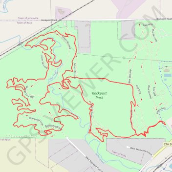
Rockport Park Loop MTB
- Distance: 8.6 Km
- Elevation gain: 115 m
- Maximum elevation: 262 m
- Elevation loss: 115 m
- Minimum elevation: 236 m
- Moving time: 50 m 24 s
- Moving speed: 10.2 Km/h
- Maximum speed: 25.3 Km/h
- Total time: 51 m 9 s
- Global speed: 10.1 Km/h
Interactive trail map
Trail profile
- Distance: 8.6 Km
- Elevation gain: 115 m
- Maximum elevation: 262 m
- Elevation loss: 115 m
- Minimum elevation: 236 m
- Moving time: 50 m 24 s
- Moving speed: 10.2 Km/h
- Maximum speed: 25.3 Km/h
- Total time: 51 m 9 s
- Global speed: 10.1 Km/h
About this trail
Name: Rockport Park Loop MTB trail, distance, elevation, map, profile, GPS track
Coordinates: 42.66411 -89.07001 42.67117 -89.05627
Other hiking, mountain biking, running and outdoor activity trails
Click on a trail to view its statistics, map and profile.
Rockport Park MTB
United States > Wisconsin > Rock County
Distance: 13.4 Km • Elevation gain: 113 m • Maximum elevation: 263 m