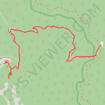
Hawksbill Trail in Linville Gorge Wilderness
The Hawksbill Trail in Linville Gorge offers a rewarding hiking experience that begins with a gradual climb through a forested path lined with rhododendron and hardwood trees. As you ascend, the trail becomes steeper and rockier, with the final stretch requiring a bit of a scramble before reaching the summit. From the summit, two distinct vantage points provide breathtaking views of the Linville Gorge, including striking perspectives of Table Rock, Shortoff Mountain, and the distant Blue Ridge peaks, all framed by rugged cliffs and dramatic drop-offs. #Hiking #Mountain #Forest #Nature #Gorge #Overlook
- Distance: 3.6 Km
- Elevation gain: 212 m
- Maximum elevation: 1,202 m
- Elevation loss: 212 m
- Minimum elevation: 1,007 m
- Moving time: 1 h 9 m
- Moving speed: 3.1 Km/h
- Maximum speed: 6.2 Km/h
- Total time: 1 h 31 m
- Global speed: 2.3 Km/h
Interactive trail map
Trail profile
- Distance: 3.6 Km
- Elevation gain: 212 m
- Maximum elevation: 1,202 m
- Elevation loss: 212 m
- Minimum elevation: 1,007 m
- Moving time: 1 h 9 m
- Moving speed: 3.1 Km/h
- Maximum speed: 6.2 Km/h
- Total time: 1 h 31 m
- Global speed: 2.3 Km/h
About this trail
Name: Hawksbill Trail in Linville Gorge Wilderness trail, distance, elevation, map, profile, GPS track
Start: 6097, Roses Creek Road, Burke County, North Carolina, 28657, United States (35.91459 -81.87836)
End: Hawksbill Trail, Burke County, North Carolina, United States (35.91457 -81.87845)
Coordinates: 35.91233 -81.88649 35.91592 -81.87836
Other hiking, mountain biking, running and outdoor activity trails
Click on a trail to view its statistics, map and profile.
Hawksbill Mountain Trail in Linville Gorge Wilderness
United States > North Carolina > Burke County
The Hawksbill Mountain Trail offers hikers an accessible but rewarding adventure in the heart of the Linville Gorge Wilderness. As you climb through rhododendron-filled forests, you’ll encounter rock outcroppings that reward you with breathtaking panoramic views of the gorge below, including vistas of Table…
Distance: 3.4 Km • Elevation gain: 207 m • Maximum elevation: 1,202 m