Twin Sisters Peak from Lily Lake
Rocky Moutains. #Hiking #RockyMountains
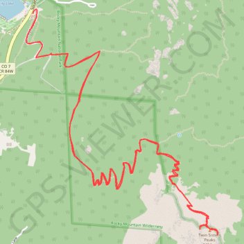
- Distance: 12.2 Km
- Elevation gain: 744 m
- Maximum elevation: 3,464 m
- Elevation loss: 744 m
- Minimum elevation: 2,726 m
Interactive trail map
Trail profile
- Distance: 12.2 Km
- Elevation gain: 744 m
- Maximum elevation: 3,464 m
- Elevation loss: 744 m
- Minimum elevation: 2,726 m
About this trail
Name: Twin Sisters Peak from Lily Lake trail, distance, elevation, map, profile, GPS track
Coordinates: 40.28851 -105.53787 40.30683 -105.51744
Other hiking, mountain biking, running and outdoor activity trails
Click on a trail to view its statistics, map and profile.
Twin Sisters Trail in Rocky Mountain National Park
United States > Colorado > Larimer County
The Twin Sisters Trail in Rocky Mountain National Park offers a challenging yet rewarding hike with stunning panoramic views. As hikers ascend through dense forests, they are treated to glimpses of Longs Peak, Estes Cone, and other peaks of the Front Range, especially after passing the treeline. The trail…
Distance: 11.2 Km • Elevation gain: 688 m • Maximum elevation: 3,464 m