Thank you for supporting this site ❤️
Make a donation
Make a donation
Gear up for your next adventure:
As an Amazon Associate, this site earns from qualifying purchases at no extra cost to you.
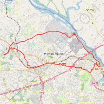
Long range bike
Loop bike from Evans to Savannah River via Savannah River Rapids Park, Augusta Canal Trail, Eisenhower Park and Augusta. #Bike #Loop #City #River
- Distance: 39.7 Km
- Elevation gain: 309 m
- Maximum elevation: 139 m
- Elevation loss: 308 m
- Minimum elevation: 39 m
- Moving time: 3 h 19 m
- Moving speed: 12.0 Km/h
- Maximum speed: 27.7 Km/h
- Total time: 5 h 48 m
- Global speed: 6.8 Km/h
Interactive trail map
Thank you for supporting this site ❤️
Make a donation
Make a donation
Gear up for your next adventure:
As an Amazon Associate, this site earns from qualifying purchases at no extra cost to you.
Trail profile
- Distance: 39.7 Km
- Elevation gain: 309 m
- Maximum elevation: 139 m
- Elevation loss: 308 m
- Minimum elevation: 39 m
- Moving time: 3 h 19 m
- Moving speed: 12.0 Km/h
- Maximum speed: 27.7 Km/h
- Total time: 5 h 48 m
- Global speed: 6.8 Km/h
Thank you for supporting this site ❤️
Make a donation
Make a donation
Gear up for your next adventure:
As an Amazon Associate, this site earns from qualifying purchases at no extra cost to you.
About this trail
Name: Long range bike trail, distance, elevation, map, profile, GPS track
Start: 340, North Belair Road, Evans, Columbia County, Georgia, 30809, United States (33.52611 -82.13788)
Coordinates: 33.50509 -82.13788 33.55389 -82.00249
Thank you for supporting this site ❤️
Make a donation
Make a donation
Gear up for your next adventure:
As an Amazon Associate, this site earns from qualifying purchases at no extra cost to you.