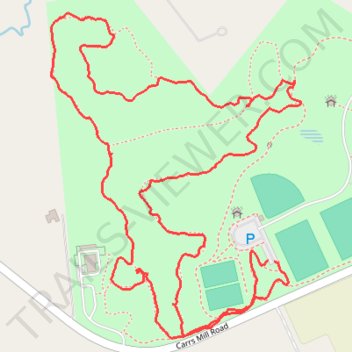
Western Regional Park
- Distance: 3.6 Km
- Elevation gain: 48 m
- Maximum elevation: 181 m
- Elevation loss: 48 m
- Minimum elevation: 156 m
- Moving time: 57 m 51 s
- Moving speed: 3.8 Km/h
- Maximum speed: 8.2 Km/h
- Total time: 1 h 12 m
- Global speed: 3.0 Km/h
Interactive trail map
Trail profile
- Distance: 3.6 Km
- Elevation gain: 48 m
- Maximum elevation: 181 m
- Elevation loss: 48 m
- Minimum elevation: 156 m
- Moving time: 57 m 51 s
- Moving speed: 3.8 Km/h
- Maximum speed: 8.2 Km/h
- Total time: 1 h 12 m
- Global speed: 3.0 Km/h
About this trail
Name: Western Regional Park trail, distance, elevation, map, profile, GPS track
Start: Carrs Mill Road, Carrs Mill, Howard County, Maryland, 21797, United States (39.30486 -77.03163)
End: Carrs Mill Road, Carrs Mill, Howard County, Maryland, 21797, United States (39.30488 -77.03178)
Coordinates: 39.30339 -77.03708 39.30955 -77.03098