Make a donation
Gear up for your next adventure:
As an Amazon Associate, this site earns from qualifying purchases at no extra cost to you.
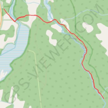
Siffleur Falls Trail
Kootenay Plains Ecological Reserve. #Hiking #Snowshoeing #River #Falls #Forest
- Distance: 9.6 Km
- Elevation gain: 189 m
- Maximum elevation: 1,427 m
- Elevation loss: 189 m
- Minimum elevation: 1,332 m
Interactive trail map
Make a donation
Gear up for your next adventure:
As an Amazon Associate, this site earns from qualifying purchases at no extra cost to you.
Trail profile
- Distance: 9.6 Km
- Elevation gain: 189 m
- Maximum elevation: 1,427 m
- Elevation loss: 189 m
- Minimum elevation: 1,332 m
Make a donation
Gear up for your next adventure:
As an Amazon Associate, this site earns from qualifying purchases at no extra cost to you.
About this trail
Name: Siffleur Falls Trail trail, distance, elevation, map, profile, GPS track
Coordinates: 52.02768 -116.41168 52.05082 -116.36993
Make a donation
Gear up for your next adventure:
As an Amazon Associate, this site earns from qualifying purchases at no extra cost to you.
Other hiking, mountain biking, running and outdoor activity trails
Click on a trail to view its statistics, map and profile.
Ardennes Peak, Normandy Peak and Stan Waters Peak Traverse
Canada > Alberta > Clearwater County
Scrambling, mountain, peak
Distance: 17.7 Km • Elevation gain: 1,590 m • Maximum elevation: 2,479 m
Ascent of Voltage Peak in snow conditions
Canada > Alberta > Clearwater County
Scrambling, mountain, peak
Distance: 29.8 Km • Elevation gain: 1,525 m • Maximum elevation: 2,686 m
Mount William Booth ascent
Canada > Alberta > Clearwater County
Scrambling, mountain, peak
Distance: 23.0 Km • Elevation gain: 1,506 m • Maximum elevation: 2,698 m