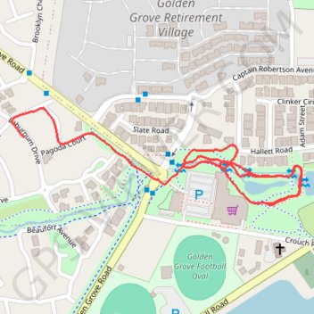
The Stables Reserve - Walk
- Distance: 1.9 Km
- Elevation gain: 22 m
- Maximum elevation: 204 m
- Elevation loss: 32 m
- Minimum elevation: 187 m
- Moving time: 23 m 46 s
- Moving speed: 4.9 Km/h
- Maximum speed: 6.2 Km/h
- Total time: 23 m 46 s
- Global speed: 4.9 Km/h
Interactive trail map
Trail profile
- Distance: 1.9 Km
- Elevation gain: 22 m
- Maximum elevation: 204 m
- Elevation loss: 32 m
- Minimum elevation: 187 m
- Moving time: 23 m 46 s
- Moving speed: 4.9 Km/h
- Maximum speed: 6.2 Km/h
- Total time: 23 m 46 s
- Global speed: 4.9 Km/h
About this trail
Name: The Stables Reserve - Walk trail, distance, elevation, map, profile, GPS track
Coordinates: -34.77360 138.72363 -34.77150 138.73130
Topography: Adelaide topographic map, elevation, terrain
Other hiking, mountain biking, running and outdoor activity trails
Click on a trail to view its statistics, map and profile.
Cobbler Creek Recreation Park and Martindale Reserve
Australia > South Australia > Adelaide
Distance: 30.1 Km • Elevation gain: 671 m • Maximum elevation: 219 m
Cobbler Creek Recreation Park
Australia > South Australia > Adelaide
Distance: 20.2 Km • Elevation gain: 358 m • Maximum elevation: 219 m
Dry Creek to the Triangle
Australia > South Australia > Adelaide
Distance: 21.3 Km • Elevation gain: 174 m • Maximum elevation: 204 m
Greenwith Rando Walk
Australia > South Australia > Adelaide
Distance: 10.1 Km • Elevation gain: 210 m • Maximum elevation: 217 m
Dry Creek Trail
Australia > South Australia > Adelaide
Distance: 22.5 Km • Elevation gain: 263 m • Maximum elevation: 204 m