Thank you for supporting this site ❤️
Make a donation
Make a donation
Gear up for your next adventure:
As an Amazon Associate, this site earns from qualifying purchases at no extra cost to you.
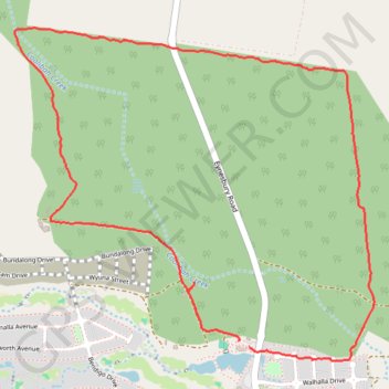
Eynesbury Trail
Eynesbury walk
- Distance: 5.9 Km
- Elevation gain: 33 m
- Maximum elevation: 102 m
- Elevation loss: 33 m
- Minimum elevation: 84 m
- Moving time: 1 h 36 m
- Moving speed: 3.7 Km/h
- Maximum speed: 5.3 Km/h
- Total time: 1 h 40 m
- Global speed: 3.5 Km/h
Interactive trail map
Thank you for supporting this site ❤️
Make a donation
Make a donation
Gear up for your next adventure:
As an Amazon Associate, this site earns from qualifying purchases at no extra cost to you.
Trail profile
- Distance: 5.9 Km
- Elevation gain: 33 m
- Maximum elevation: 102 m
- Elevation loss: 33 m
- Minimum elevation: 84 m
- Moving time: 1 h 36 m
- Moving speed: 3.7 Km/h
- Maximum speed: 5.3 Km/h
- Total time: 1 h 40 m
- Global speed: 3.5 Km/h
Thank you for supporting this site ❤️
Make a donation
Make a donation
Gear up for your next adventure:
As an Amazon Associate, this site earns from qualifying purchases at no extra cost to you.
About this trail
Name: Eynesbury Trail trail, distance, elevation, map, profile, GPS track
Coordinates: -37.78924 144.55418 -37.77505 144.57354
Topography: Melbourne topographic map, elevation, terrain
Thank you for supporting this site ❤️
Make a donation
Make a donation
Gear up for your next adventure:
📣High-Decibel Survival Whistles - Signaling tool for rescue that carries much further than a human voice
As an Amazon Associate, this site earns from qualifying purchases at no extra cost to you.