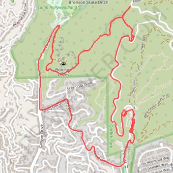
Griffith Park from Bronson Caves
Loop hike through Griffith Park via Bronson Caves Trail, The Tiffany & Co. Foundation Overlook and Western Canyon Road. #Hiking #Loop #Park #Nature #Forest #Mountain #Overlook
- Distance: 7.6 Km
- Elevation gain: 283 m
- Maximum elevation: 358 m
- Elevation loss: 283 m
- Minimum elevation: 171 m
- Moving time: 1 h 40 m
- Moving speed: 4.5 Km/h
- Maximum speed: 11.0 Km/h
- Total time: 1 h 50 m
- Global speed: 4.1 Km/h
Interactive trail map
Trail profile
- Distance: 7.6 Km
- Elevation gain: 283 m
- Maximum elevation: 358 m
- Elevation loss: 283 m
- Minimum elevation: 171 m
- Moving time: 1 h 40 m
- Moving speed: 4.5 Km/h
- Maximum speed: 11.0 Km/h
- Total time: 1 h 50 m
- Global speed: 4.1 Km/h
About this trail
Name: Griffith Park from Bronson Caves trail, distance, elevation, map, profile, GPS track
Coordinates: 34.11235 -118.31642 34.12600 -118.30649
Other hiking, mountain biking, running and outdoor activity trails
Click on a trail to view its statistics, map and profile.
Hollywood Sign and Mount Lee
United States > California > Los Angeles County > Los Angeles
Starting from Canyon Drive in Griffith Park, the route enters Brush Canyon on the broad Brush Canyon Trail, leaving the Bronson Canyon area behind as it rises through open chaparral, dry ravine scenery, and the wooded-looking folds of the Hollywood Hills. Higher up, the trail bends across the hillside to meet…
Distance: 9.6 Km • Elevation gain: 441 m • Maximum elevation: 498 m
Hollywood Sign Viewpoint via Brush Canyon Trail and Mulholland Trail in Griffith Park
United States > California > Los Angeles County > Los Angeles
The Brush Canyon Trail and Mulholland Fire Road offer hikers a scenic journey through Griffith Park, culminating in a close-up view of the iconic Hollywood Sign. Along the way, hikers can enjoy panoramic vistas of Los Angeles, including downtown skyscrapers, the San Fernando Valley, and, on clear days, the…
Distance: 8.2 Km • Elevation gain: 379 m • Maximum elevation: 389 m
Griffith Observatory Loop via East and West Observatory Trails in Griffith Park
United States > California > Los Angeles County > Los Angeles
The Griffith Observatory Loop via the East and West Observatory Trails in Griffith Park offers hikers a rewarding experience with panoramic views of Los Angeles. Along the route, one can observe the iconic Griffith Observatory, the Hollywood Sign, and the expansive Los Angeles skyline. The trails also provide…
Distance: 3.8 Km • Elevation gain: 208 m • Maximum elevation: 345 m
Hollywood Sign and Mount Lee Trail in Griffith Park
United States > California > Los Angeles County > Los Angeles
Hiking from Canyon Drive via Brush Canyon and Mulholland Trails in Griffith Park offers an immersive journey through the natural landscapes leading up to the iconic Hollywood Sign perched on Mount Lee. Along the trail, hikers are treated to panoramic vistas of Los Angeles, including sights of the Griffith…
Distance: 9.5 Km • Elevation gain: 432 m • Maximum elevation: 498 m
Wonder View Trail
United States > California > Los Angeles County > Los Angeles
Hike from Lake Hollywood to Griffith Observatory via Burbank Peak Trail, Burbank Peak, Aileen Getty Ridge Trail, Cathuenga Peak, Hugh Hefner Overlook, Mount Lee, Hollywood Sign, Mount Lee Drive, Mulholland Trail, Mount Hollywood Drive and West Observatory Road in the Griffith Park. #Hiking #Hollywood #Nature…
Distance: 9.2 Km • Elevation gain: 494 m • Maximum elevation: 527 m