Make a donation
Gear up for your next adventure:
As an Amazon Associate, this site earns from qualifying purchases at no extra cost to you.
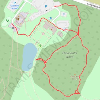
Pheasants's Wood Loop in Mugdock Country Park
- Distance: 1.2 Km
- Elevation gain: 15 m
- Maximum elevation: 178 m
- Elevation loss: 17 m
- Minimum elevation: 166 m
- Moving time: 20 m 23 s
- Moving speed: 3.5 Km/h
- Maximum speed: 6.0 Km/h
- Total time: 20 m 23 s
- Global speed: 3.5 Km/h
Interactive trail map
Make a donation
Gear up for your next adventure:
As an Amazon Associate, this site earns from qualifying purchases at no extra cost to you.
Trail profile
- Distance: 1.2 Km
- Elevation gain: 15 m
- Maximum elevation: 178 m
- Elevation loss: 17 m
- Minimum elevation: 166 m
- Moving time: 20 m 23 s
- Moving speed: 3.5 Km/h
- Maximum speed: 6.0 Km/h
- Total time: 20 m 23 s
- Global speed: 3.5 Km/h
Make a donation
Gear up for your next adventure:
As an Amazon Associate, this site earns from qualifying purchases at no extra cost to you.
About this trail
Name: Pheasants's Wood Loop in Mugdock Country Park trail, distance, elevation, map, profile, GPS track
Coordinates: 55.97024 -4.33112 55.97294 -4.32712
Make a donation
Gear up for your next adventure:
As an Amazon Associate, this site earns from qualifying purchases at no extra cost to you.
Other hiking, mountain biking, running and outdoor activity trails
Click on a trail to view its statistics, map and profile.
West Highland Way between Milngavie and Craigallian Loch
United Kingdom > Scotland > East Dunbartonshire > Milngavie
Distance: 7.4 Km • Elevation gain: 83 m • Maximum elevation: 117 m
Loop walk in Mugdock County Park
United Kingdom > Scotland > Stirling > Mugdock
Distance: 4.6 Km • Elevation gain: 44 m • Maximum elevation: 179 m