Thank you for supporting this site ❤️
Make a donation
Make a donation
Gear up for your next adventure:
As an Amazon Associate, this site earns from qualifying purchases at no extra cost to you.
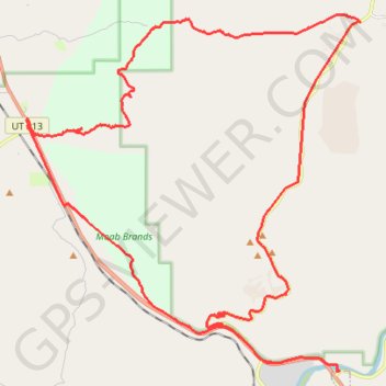
Arches via Zephyr and Willow Springs, Moab, UT
Loop MTB from Colorado River in the Arches National Park. #MTB #Loop #Park #Nature #Desert
- Distance: 50.7 Km
- Elevation gain: 879 m
- Maximum elevation: 1,546 m
- Elevation loss: 880 m
- Minimum elevation: 1,207 m
- Moving time: 3 h 7 m
- Moving speed: 16.2 Km/h
- Maximum speed: 67.0 Km/h
- Total time: 4 h 4 m
- Global speed: 12.4 Km/h
Interactive trail map
Thank you for supporting this site ❤️
Make a donation
Make a donation
Gear up for your next adventure:
As an Amazon Associate, this site earns from qualifying purchases at no extra cost to you.
Trail profile
- Distance: 50.7 Km
- Elevation gain: 879 m
- Maximum elevation: 1,546 m
- Elevation loss: 880 m
- Minimum elevation: 1,207 m
- Moving time: 3 h 7 m
- Moving speed: 16.2 Km/h
- Maximum speed: 67.0 Km/h
- Total time: 4 h 4 m
- Global speed: 12.4 Km/h
Thank you for supporting this site ❤️
Make a donation
Make a donation
Gear up for your next adventure:
As an Amazon Associate, this site earns from qualifying purchases at no extra cost to you.
About this trail
Name: Arches via Zephyr and Willow Springs, Moab, UT trail, distance, elevation, map, profile, GPS track
Coordinates: 38.60294 -109.68714 38.70369 -109.56646
Thank you for supporting this site ❤️
Make a donation
Make a donation
Gear up for your next adventure:
As an Amazon Associate, this site earns from qualifying purchases at no extra cost to you.