Thank you for supporting this site ❤️
Make a donation
Make a donation
Gear up for your next adventure:
As an Amazon Associate, this site earns from qualifying purchases at no extra cost to you.
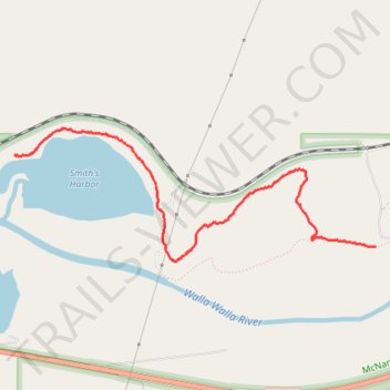
Wallula horse trail and hunting roads
- Distance: 4.2 Km
- Elevation gain: 19 m
- Maximum elevation: 118 m
- Elevation loss: 25 m
- Minimum elevation: 104 m
- Moving time: 50 m 34 s
- Moving speed: 5.0 Km/h
- Maximum speed: 23.8 Km/h
- Total time: 53 m 4 s
- Global speed: 4.8 Km/h
Interactive trail map
Thank you for supporting this site ❤️
Make a donation
Make a donation
Gear up for your next adventure:
As an Amazon Associate, this site earns from qualifying purchases at no extra cost to you.
Trail profile
- Distance: 4.2 Km
- Elevation gain: 19 m
- Maximum elevation: 118 m
- Elevation loss: 25 m
- Minimum elevation: 104 m
- Moving time: 50 m 34 s
- Moving speed: 5.0 Km/h
- Maximum speed: 23.8 Km/h
- Total time: 53 m 4 s
- Global speed: 4.8 Km/h
Thank you for supporting this site ❤️
Make a donation
Make a donation
Gear up for your next adventure:
As an Amazon Associate, this site earns from qualifying purchases at no extra cost to you.
About this trail
Name: Wallula horse trail and hunting roads trail, distance, elevation, map, profile, GPS track
Start: 221, North Shore Road, Walla Walla County, Washington, 99362, United States (46.06818 -118.89981)
Coordinates: 46.06134 -118.89981 46.06992 -118.86621
Thank you for supporting this site ❤️
Make a donation
Make a donation
Gear up for your next adventure:
As an Amazon Associate, this site earns from qualifying purchases at no extra cost to you.