Rockleigh Cycle Challenge
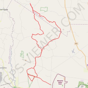
Interactive trail map
Trail profile
- Distance: 65.8 Km
- Elevation gain: 864 m
- Maximum elevation: 307 m
- Elevation loss: 864 m
- Minimum elevation: 109 m
About this trail
Name: Rockleigh Cycle Challenge trail, distance, elevation, map, profile, GPS track
Start: Monarto, The Rural City of Murray Bridge, South Australia, 5254, Australia (-35.10428 139.13091)
End: Monarto, The Rural City of Murray Bridge, South Australia, 5254, Australia (-35.10428 139.13092)
Coordinates: -35.10488 139.07132 -34.93773 139.15691
Topography: The Rural City of Murray Bridge topographic map, elevation, terrain
Other hiking, mountain biking, running and outdoor activity trails
Click on a trail to view its statistics, map and profile.