Thank you for supporting this site ❤️
Make a donation
Make a donation
Gear up for your next adventure:
As an Amazon Associate, this site earns from qualifying purchases at no extra cost to you.
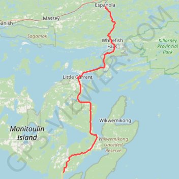
Espanola - South Baymouth
Manitoulin Island. #Bike #Espanola #SouthBaymouth #Manitoulin
- Distance: 106.5 Km
- Elevation gain: 715 m
- Maximum elevation: 272 m
- Elevation loss: 723 m
- Minimum elevation: 174 m
Interactive trail map
Thank you for supporting this site ❤️
Make a donation
Make a donation
Gear up for your next adventure:
As an Amazon Associate, this site earns from qualifying purchases at no extra cost to you.
Trail profile
- Distance: 106.5 Km
- Elevation gain: 715 m
- Maximum elevation: 272 m
- Elevation loss: 723 m
- Minimum elevation: 174 m
Thank you for supporting this site ❤️
Make a donation
Make a donation
Gear up for your next adventure:
As an Amazon Associate, this site earns from qualifying purchases at no extra cost to you.
About this trail
Name: Espanola - South Baymouth trail, distance, elevation, map, profile, GPS track
Coordinates: 45.60132 -82.00523 46.25772 -81.71099
Thank you for supporting this site ❤️
Make a donation
Make a donation
Gear up for your next adventure:
As an Amazon Associate, this site earns from qualifying purchases at no extra cost to you.
Other hiking, mountain biking, running and outdoor activity trails
Click on a trail to view its statistics, map and profile.