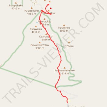
Mauna Kea's Humu'ula Trail
- Distance: 20.7 Km
- Elevation gain: 1,421 m
- Maximum elevation: 4,207 m
- Elevation loss: 1,421 m
- Minimum elevation: 2,808 m
- Moving time: 5 h 34 m
- Moving speed: 3.7 Km/h
- Maximum speed: 10.5 Km/h
- Total time: 7 h 5 m
- Global speed: 2.9 Km/h
Interactive trail map
Trail profile
- Distance: 20.7 Km
- Elevation gain: 1,421 m
- Maximum elevation: 4,207 m
- Elevation loss: 1,421 m
- Minimum elevation: 2,808 m
- Moving time: 5 h 34 m
- Moving speed: 3.7 Km/h
- Maximum speed: 10.5 Km/h
- Total time: 7 h 5 m
- Global speed: 2.9 Km/h
About this trail
Name: Mauna Kea's Humu'ula Trail trail, distance, elevation, map, profile, GPS track
Start: Mauna Kea Access Road, Hawaiʻi County, Hawaii, United States (19.75968 -155.45648)
End: Mauna Kea Access Road, Hawaiʻi County, Hawaii, United States (19.75963 -155.45645)
Coordinates: 19.75963 -155.47554 19.82333 -155.45645
Other hiking, mountain biking, running and outdoor activity trails
Click on a trail to view its statistics, map and profile.
Mauna Kea (Hawaii)
United States > Hawaii > Hawaiʻi County
Starting at the Maunakea Visitor Information Station, near Puʻukalepeamoa and Puʻuhauwahine, this demanding loop follows the Mauna Kea–Humuʻula Trail from the upper edge of the Mauna Kea Forest Reserve into a wide volcanic landscape of cinder, lava, and sparse alpine vegetation. As the route enters the…
Distance: 21.3 Km • Elevation gain: 1,256 m • Maximum elevation: 4,037 m