Thank you for supporting this site ❤️
Make a donation
Make a donation
Gear up for your next adventure:
🧭Global Orienteering Compass - High-precision liquid-filled compasses for accurate map reading and navigation
As an Amazon Associate, this site earns from qualifying purchases at no extra cost to you.
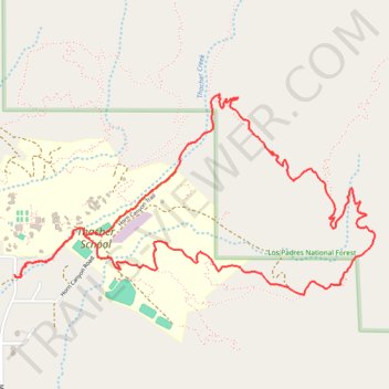
Morgan Barnes trail
- Distance: 7.5 Km
- Elevation gain: 426 m
- Maximum elevation: 707 m
- Elevation loss: 427 m
- Minimum elevation: 401 m
- Moving time: 1 h 52 m
- Moving speed: 4.0 Km/h
- Maximum speed: 8.9 Km/h
- Total time: 2 h 3 m
- Global speed: 3.6 Km/h
Interactive trail map
Thank you for supporting this site ❤️
Make a donation
Make a donation
Gear up for your next adventure:
As an Amazon Associate, this site earns from qualifying purchases at no extra cost to you.
Trail profile
- Distance: 7.5 Km
- Elevation gain: 426 m
- Maximum elevation: 707 m
- Elevation loss: 427 m
- Minimum elevation: 401 m
- Moving time: 1 h 52 m
- Moving speed: 4.0 Km/h
- Maximum speed: 8.9 Km/h
- Total time: 2 h 3 m
- Global speed: 3.6 Km/h
Thank you for supporting this site ❤️
Make a donation
Make a donation
Gear up for your next adventure:
As an Amazon Associate, this site earns from qualifying purchases at no extra cost to you.
About this trail
Name: Morgan Barnes trail trail, distance, elevation, map, profile, GPS track
Start: Horn Canyon Access Trail, Ventura County, California, 93024, United States (34.46175 -119.18300)
End: McAndrew Road, Ventura County, California, 93024, United States (34.46185 -119.18339)
Coordinates: 34.46082 -119.18339 34.47087 -119.16150
Thank you for supporting this site ❤️
Make a donation
Make a donation
Gear up for your next adventure:
As an Amazon Associate, this site earns from qualifying purchases at no extra cost to you.