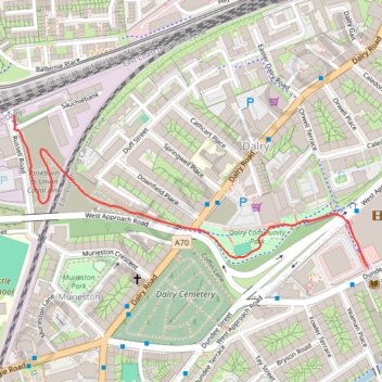
Dalry path up
- Distance: 1.1 Km
- Elevation gain: 25 m
- Maximum elevation: 75 m
- Elevation loss: 0 m
- Minimum elevation: 50 m
- Moving time: 11 m 25 s
- Moving speed: 5.5 Km/h
- Maximum speed: 24.0 Km/h
- Total time: 11 m 25 s
- Global speed: 5.5 Km/h
Interactive trail map
Trail profile
- Distance: 1.1 Km
- Elevation gain: 25 m
- Maximum elevation: 75 m
- Elevation loss: 0 m
- Minimum elevation: 50 m
- Moving time: 11 m 25 s
- Moving speed: 5.5 Km/h
- Maximum speed: 24.0 Km/h
- Total time: 11 m 25 s
- Global speed: 5.5 Km/h
About this trail
Name: Dalry path up trail, distance, elevation, map, profile, GPS track
Start: Russell Road, Dalry, City of Edinburgh, Scotland, EH11 2LS, United Kingdom (55.94291 -3.22894)
Coordinates: 55.94040 -3.22894 55.94291 -3.21854
Other hiking, mountain biking, running and outdoor activity trails
Click on a trail to view its statistics, map and profile.
Cycleroute Edinburgh
United Kingdom > Scotland > City of Edinburgh
Summer!
Distance: 76.4 Km • Elevation gain: 886 m • Maximum elevation: 325 m