Big Stones Peak and Infinite Stones Peak traverse
Scrambling, mountain, peak
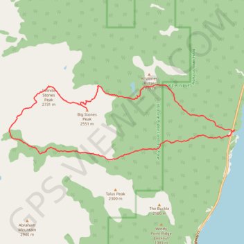
- Distance: 19.7 Km
- Elevation gain: 1,788 m
- Maximum elevation: 2,725 m
- Elevation loss: 1,788 m
- Minimum elevation: 1,329 m
- Moving time: 9 h 13 m
- Moving speed: 2.1 Km/h
- Maximum speed: 6.5 Km/h
- Total time: 14 h 10 m
- Global speed: 1.4 Km/h
Interactive trail map
Trail profile
- Distance: 19.7 Km
- Elevation gain: 1,788 m
- Maximum elevation: 2,725 m
- Elevation loss: 1,788 m
- Minimum elevation: 1,329 m
- Moving time: 9 h 13 m
- Moving speed: 2.1 Km/h
- Maximum speed: 6.5 Km/h
- Total time: 14 h 10 m
- Global speed: 1.4 Km/h
About this trail
Name: Big Stones Peak and Infinite Stones Peak traverse trail, distance, elevation, map, profile, GPS track
Start: Highway 11, Clearwater County, Alberta, Canada (52.29153 -116.37394)
End: Highway 11, Clearwater County, Alberta, Canada (52.29150 -116.37401)
Coordinates: 52.28355 -116.47275 52.30370 -116.37394
Other hiking, mountain biking, running and outdoor activity trails
Click on a trail to view its statistics, map and profile.
Tershishner Peak route
Canada > Alberta > Clearwater County
Distance: 27.5 Km • Elevation gain: 2,629 m • Maximum elevation: 2,815 m