Thank you for supporting this site ❤️
Make a donation
Make a donation
Gear up for your next adventure:
As an Amazon Associate, this site earns from qualifying purchases at no extra cost to you.
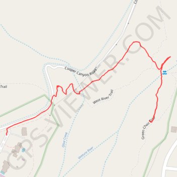
New river trails
- Distance: 1.1 Km
- Elevation gain: 27 m
- Maximum elevation: 218 m
- Elevation loss: 4 m
- Minimum elevation: 190 m
- Moving time: 19 m 8 s
- Moving speed: 3.5 Km/h
- Maximum speed: 7.4 Km/h
- Total time: 21 m 8 s
- Global speed: 3.1 Km/h
Interactive trail map
Thank you for supporting this site ❤️
Make a donation
Make a donation
Gear up for your next adventure:
As an Amazon Associate, this site earns from qualifying purchases at no extra cost to you.
Trail profile
- Distance: 1.1 Km
- Elevation gain: 27 m
- Maximum elevation: 218 m
- Elevation loss: 4 m
- Minimum elevation: 190 m
- Moving time: 19 m 8 s
- Moving speed: 3.5 Km/h
- Maximum speed: 7.4 Km/h
- Total time: 21 m 8 s
- Global speed: 3.1 Km/h
Thank you for supporting this site ❤️
Make a donation
Make a donation
Gear up for your next adventure:
As an Amazon Associate, this site earns from qualifying purchases at no extra cost to you.
About this trail
Name: New river trails trail, distance, elevation, map, profile, GPS track
Start: Green Chair Trail, Ventura County, California, 93023, United States (34.44175 -119.29699)
Coordinates: 34.44099 -119.30206 34.44360 -119.29652
Thank you for supporting this site ❤️
Make a donation
Make a donation
Gear up for your next adventure:
As an Amazon Associate, this site earns from qualifying purchases at no extra cost to you.