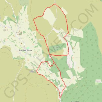
Hartoft End Loop
Ryedale Mountain Biking
- Distance: 19.5 Km
- Elevation gain: 421 m
- Maximum elevation: 330 m
- Elevation loss: 422 m
- Minimum elevation: 102 m
- Moving time: 1 h 45 m
- Moving speed: 11.1 Km/h
- Maximum speed: 37.6 Km/h
- Total time: 2 h 25 m
- Global speed: 8.1 Km/h
Interactive trail map
Trail profile
- Distance: 19.5 Km
- Elevation gain: 421 m
- Maximum elevation: 330 m
- Elevation loss: 422 m
- Minimum elevation: 102 m
- Moving time: 1 h 45 m
- Moving speed: 11.1 Km/h
- Maximum speed: 37.6 Km/h
- Total time: 2 h 25 m
- Global speed: 8.1 Km/h
About this trail
Name: Hartoft End Loop trail, distance, elevation, map, profile, GPS track
Coordinates: 54.32385 -0.87888 54.38297 -0.84109
Other hiking, mountain biking, running and outdoor activity trails
Click on a trail to view its statistics, map and profile.
Hartoft End Loop
United Kingdom > England > North Yorkshire > Rosedale Abbey
Distance: 20.7 Km • Elevation gain: 499 m • Maximum elevation: 372 m
Sinnington MTB loop
United Kingdom > England > North Yorkshire > Sinnington
Distance: 22.8 Km • Elevation gain: 464 m • Maximum elevation: 276 m
Hartoft Rigg
United Kingdom > England > North Yorkshire > Rosedale Abbey
Distance: 9.4 Km • Elevation gain: 255 m • Maximum elevation: 287 m
Farndale
United Kingdom > England > North Yorkshire > Appleton-le-Moors
Ryedale Mountain Biking
Distance: 52.9 Km • Elevation gain: 1,251 m • Maximum elevation: 407 m