Import a GPX file

Mounts Democrat, Cameron, Lincoln and Bross from Kite Lake

Pike National Forest. #Hiking #Mountain #Forest #Lake #Nature

  • Distance: 11.6 Km
  • Elevation gain: 1,004 m
  • Maximum elevation: 4,344 m
  • Elevation loss: 1,004 m
  • Minimum elevation: 3,664 m

Interactive trail map

Trail profile

  • Distance: 11.6 Km
  • Elevation gain: 1,004 m
  • Maximum elevation: 4,344 m
  • Elevation loss: 1,004 m
  • Minimum elevation: 3,664 m

About this trail
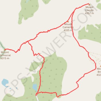
Name: Mounts Democrat, Cameron, Lincoln and Bross from Kite Lake trail, distance, elevation, map, profile, GPS track

Start: County Road 8, Alma, Park County, Colorado, 80420, United States (39.32743 -106.12935)

End: County Road 8, Alma, Park County, Colorado, 80420, United States (39.32743 -106.12935)

Coordinates: 39.32711 -106.13992 39.35152 -106.10917

Gear up for your next adventure:

🧭Global Orienteering Compass - High-precision liquid-filled compasses for accurate map reading and navigation
🕶️Polarized Outdoor Sunglasses - Reduce glare from rocks and water for better visual navigation
🔦LED Torches - LED torches for outdoor use
🔋Solar Power Banks - Charge your phone and GPS using the sun while deep in the bush
🆘Personal Locator Beacons (PLB) - Satellite emergency beacons for life-saving help in areas with no mobile coverage

As an Amazon Associate, this site earns from qualifying purchases at no extra cost to you.