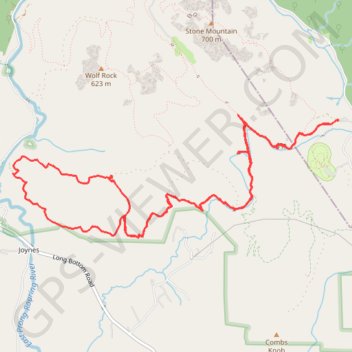
Stone Mountain - Big Sandy Creek
Running
- Distance: 14.7 Km
- Elevation gain: 405 m
- Maximum elevation: 571 m
- Elevation loss: 404 m
- Minimum elevation: 397 m
- Moving time: 2 h 4 m
- Moving speed: 7.0 Km/h
- Maximum speed: 16.4 Km/h
- Total time: 2 h 14 m
- Global speed: 6.5 Km/h
Interactive trail map
Trail profile
- Distance: 14.7 Km
- Elevation gain: 405 m
- Maximum elevation: 571 m
- Elevation loss: 404 m
- Minimum elevation: 397 m
- Moving time: 2 h 4 m
- Moving speed: 7.0 Km/h
- Maximum speed: 16.4 Km/h
- Total time: 2 h 14 m
- Global speed: 6.5 Km/h
About this trail
Name: Stone Mountain - Big Sandy Creek trail, distance, elevation, map, profile, GPS track
Start: Connector Trail, Alleghany County, North Carolina, 28668, United States (36.38388 -81.02809)
End: Connector Trail, Alleghany County, North Carolina, 28668, United States (36.38395 -81.02801)
Coordinates: 36.37214 -81.06864 36.38452 -81.02801