Bald Mountain and Artists Bluff Loop Trail in Franconia Notch State Park
The Bald Mountain and Artists Bluff Loop Trail in Franconia Notch State Park offers hikers a rewarding experience with panoramic vistas. From the summit of Bald Mountain, enjoy expansive views of Echo Lake and the surrounding White Mountains. Continuing along the trail, Artists Bluff provides a unique vantage point overlooking the vibrant foliage of the Franconia Notch area, especially stunning during the fall season. The trail features rocky terrain and moderate elevation changes, making it suitable for hikers seeking a short yet invigorating adventure. #Hiking #Mountain #Forest #Nature #Loop #Overlook #Lake
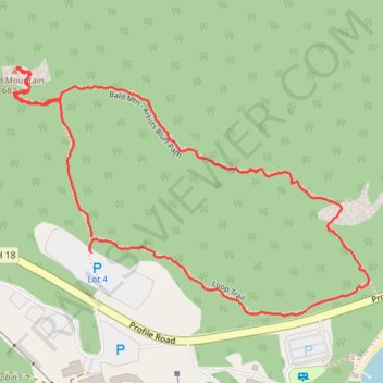
- Distance: 2.4 Km
- Elevation gain: 111 m
- Maximum elevation: 696 m
- Elevation loss: 117 m
- Minimum elevation: 601 m
- Moving time: 40 m 44 s
- Moving speed: 3.5 Km/h
- Maximum speed: 11.9 Km/h
- Total time: 50 m 59 s
- Global speed: 2.8 Km/h
Interactive trail map
Trail profile
- Distance: 2.4 Km
- Elevation gain: 111 m
- Maximum elevation: 696 m
- Elevation loss: 117 m
- Minimum elevation: 601 m
- Moving time: 40 m 44 s
- Moving speed: 3.5 Km/h
- Maximum speed: 11.9 Km/h
- Total time: 50 m 59 s
- Global speed: 2.8 Km/h
About this trail
Name: Bald Mountain and Artists Bluff Loop Trail in Franconia Notch State Park trail, distance, elevation, map, profile, GPS track
Coordinates: 44.17857 -71.70382 44.18301 -71.69496
Other hiking, mountain biking, running and outdoor activity trails
Click on a trail to view its statistics, map and profile.
Bald Mountain and Artist's Bluff Trail Loop in Franconia Notch State Park
United States > New Hampshire > Grafton County > Franconia > South Franconia
The Bald Mountain and Artist's Bluff Trail Loop offers hikers a scenic and moderately challenging adventure. The route showcases exceptional views of Echo Lake, Cannon Mountain, and the surrounding Franconia Notch peaks, especially from the Artist's Bluff lookout, where the fall foliage reflects beautifully in…
Distance: 2.4 Km • Elevation gain: 122 m • Maximum elevation: 696 m