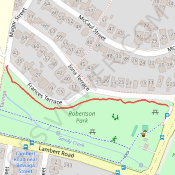
Robertson Park
Interactive trail map
Trail profile
- Distance: 0.4 Km
- Elevation gain: 4 m
- Maximum elevation: 22 m
- Elevation loss: 6 m
- Minimum elevation: 16 m
- Moving time: 5 m 8 s
- Moving speed: 4.7 Km/h
- Maximum speed: 6.9 Km/h
- Total time: 5 m 8 s
- Global speed: 4.7 Km/h
About this trail
Name: Robertson Park trail, distance, elevation, map, profile, GPS track
Start: 39, Frances Terrace, Taringa, City of Brisbane, Queensland, 4068, Australia (-27.50146 152.98704)
End: Indooroopilly Road, Taringa, Greater Brisbane, Queensland, 4068, Australia (-27.50225 152.99052)
Coordinates: -27.50230 152.98701 -27.50146 152.99052
Topography: City of Brisbane topographic map, elevation, terrain
Other hiking, mountain biking, running and outdoor activity trails
Click on a trail to view its statistics, map and profile.