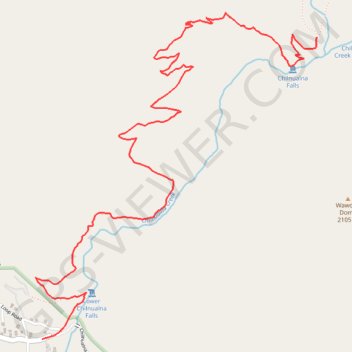
Import a GPX file

Chilnualna Falls

Hike to Chilnualna Falls from North Wawona along the Chilnualna Creek in the Yosemite National Park. #Hiking #Falls #River #Mountain #Forest #Yosemite #Park #Nature

  • Distance: 6.4 Km
  • Elevation gain: 754 m
  • Maximum elevation: 1,962 m
  • Elevation loss: 70 m
  • Minimum elevation: 1,277 m

Interactive trail map

Trail profile

  • Distance: 6.4 Km
  • Elevation gain: 754 m
  • Maximum elevation: 1,962 m
  • Elevation loss: 70 m
  • Minimum elevation: 1,277 m

About this trail

Name: Chilnualna Falls trail, distance, elevation, map, profile, GPS track

Start: 8111, Chilnualna Falls Road, North Wawona, Mariposa County, California, United States (37.54820 -119.63486)

End: Chilnualna Falls Trail, Mariposa County, California, United States (37.56517 -119.61536)

Coordinates: 37.54820 -119.63533 37.56652 -119.61536

Gear up for your next adventure:

GPS Watches - GPS watches for outdoor sports
🚁Camera Drones with GPS - Capture aerial views of the landscape to compare with topo maps
📷Backpack Camera Clips - Quick access to your camera while keeping your hands free for climbing
🔪Multitools - Compact tools for outdoor use
🎒Hiking Backpacks - Backpacks designed for hiking and trekking

As an Amazon Associate, this site earns from qualifying purchases at no extra cost to you.