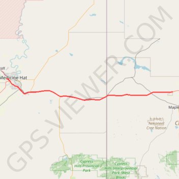
Medicine Hat - Maple Creek
#Bike #MedicineHat #MapleCreek
- Distance: 91.2 Km
- Elevation gain: 280 m
- Maximum elevation: 834 m
- Elevation loss: 222 m
- Minimum elevation: 675 m
Interactive trail map
Trail profile
- Distance: 91.2 Km
- Elevation gain: 280 m
- Maximum elevation: 834 m
- Elevation loss: 222 m
- Minimum elevation: 675 m
About this trail
Name: Medicine Hat - Maple Creek trail, distance, elevation, map, profile, GPS track
Coordinates: 49.93748 -110.72291 50.03697 -109.53057
Other hiking, mountain biking, running and outdoor activity trails
Click on a trail to view its statistics, map and profile.
Bow Island - Medicine Hat
Canada > Alberta > Town of Bow Island > Bow Island
Distance: 59.4 Km • Elevation gain: 162 m • Maximum elevation: 834 m
Maple Creek - Gull Lake
Canada > Saskatchewan > Maple Creek No. 111 > Eagle Valley
Distance: 98.8 Km • Elevation gain: 377 m • Maximum elevation: 810 m