Make a donation
Gear up for your next adventure:
As an Amazon Associate, this site earns from qualifying purchases at no extra cost to you.
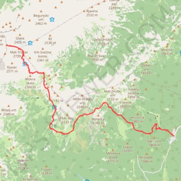
Triglav (Konjšica)
- Distance: 26.7 Km
- Elevation gain: 2,123 m
- Maximum elevation: 2,832 m
- Elevation loss: 2,125 m
- Minimum elevation: 1,344 m
Interactive trail map
Make a donation
Gear up for your next adventure:
As an Amazon Associate, this site earns from qualifying purchases at no extra cost to you.
Trail profile
- Distance: 26.7 Km
- Elevation gain: 2,123 m
- Maximum elevation: 2,832 m
- Elevation loss: 2,125 m
- Minimum elevation: 1,344 m
Make a donation
Gear up for your next adventure:
As an Amazon Associate, this site earns from qualifying purchases at no extra cost to you.
About this trail
Name: Triglav (Konjšica) trail, distance, elevation, map, profile, GPS track
Start: 906, Bohinj, 4267, Slovenia (46.34559 13.92306)
End: Rudno polje - Sport centre Triglav Pokljuka, 906, Bohinj, 4267, Slovenia (46.34561 13.92350)
Coordinates: 46.34559 13.83666 46.37824 13.92350
Make a donation
Gear up for your next adventure:
As an Amazon Associate, this site earns from qualifying purchases at no extra cost to you.
Other hiking, mountain biking, running and outdoor activity trails
Click on a trail to view its statistics, map and profile.
Bled - Bohinj
File with points/tracks from Locus Map/4.11.1
Distance: 36.6 Km • Elevation gain: 740 m • Maximum elevation: 590 m
Триглав
Distance: 6.5 Km • Elevation gain: 1,952 m • Maximum elevation: 2,833 m
TRIGLAV por la ferrata Plemanice
Slovenia > Bovec > Pri Cerkvi
Distance: 29.6 Km • Elevation gain: 3,390 m • Maximum elevation: 2,833 m
Make a donation
Gear up for your next adventure:
As an Amazon Associate, this site earns from qualifying purchases at no extra cost to you.
Alpy Julijskie - Aljazev Dom - M. Triglav, Triglav
Distance: 16.5 Km • Elevation gain: 2,458 m • Maximum elevation: 2,829 m