
Conestee Nature Preserve Loop via White Tail Trail, Sparkleberry Connector, River Otter Way and Lake Conestee Nature Trail
The Conestee Nature Preserve Loop offers a delightful hiking experience through diverse landscapes. Along this route, hikers can enjoy scenic views of wetlands, lush forests, and picturesque lakes, with abundant wildlife, including birds, turtles, and even the occasional deer. The well-maintained trails feature educational signage and observation decks, making it an excellent choice for nature enthusiasts and families alike. #Hiking #Loop #Lake #Forest #Nature
- Distance: 3.7 Km
- Elevation gain: 42 m
- Maximum elevation: 266 m
- Elevation loss: 42 m
- Minimum elevation: 241 m
- Moving time: 51 m 5 s
- Moving speed: 4.4 Km/h
- Maximum speed: 11.5 Km/h
- Total time: 56 m 19 s
- Global speed: 4.0 Km/h
Interactive trail map
Trail profile
- Distance: 3.7 Km
- Elevation gain: 42 m
- Maximum elevation: 266 m
- Elevation loss: 42 m
- Minimum elevation: 241 m
- Moving time: 51 m 5 s
- Moving speed: 4.4 Km/h
- Maximum speed: 11.5 Km/h
- Total time: 56 m 19 s
- Global speed: 4.0 Km/h
About this trail
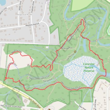
Name: Conestee Nature Preserve Loop via White Tail Trail, Sparkleberry Connector, River Otter Way and Lake Conestee Nature Trail trail, distance, elevation, map, profile, GPS track
Coordinates: 34.77420 -82.36519 34.78076 -82.35379