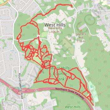
West Hills County Park
- Distance: 27.0 Km
- Elevation gain: 380 m
- Maximum elevation: 112 m
- Elevation loss: 402 m
- Minimum elevation: 48 m
- Moving time: 6 h 10 m
- Moving speed: 4.4 Km/h
- Maximum speed: 9.0 Km/h
- Total time: 9 d 1 h
- Global speed: 0.1 Km/h
Interactive trail map
Trail profile
- Distance: 27.0 Km
- Elevation gain: 380 m
- Maximum elevation: 112 m
- Elevation loss: 402 m
- Minimum elevation: 48 m
- Moving time: 6 h 10 m
- Moving speed: 4.4 Km/h
- Maximum speed: 9.0 Km/h
- Total time: 9 d 1 h
- Global speed: 0.1 Km/h
About this trail
Name: West Hills County Park trail, distance, elevation, map, profile, GPS track
Coordinates: 40.79907 -73.44306 40.82059 -73.42167
Other hiking, mountain biking, running and outdoor activity trails
Click on a trail to view its statistics, map and profile.