Bush explore of Scott Creek
Lunch Walk
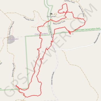
- Distance: 3.9 Km
- Elevation gain: 149 m
- Maximum elevation: 309 m
- Elevation loss: 149 m
- Minimum elevation: 237 m
- Moving time: 1 h 27 m
- Moving speed: 2.7 Km/h
- Maximum speed: 27.5 Km/h
- Total time: 1 h 45 m
- Global speed: 2.2 Km/h
Interactive trail map
Trail profile
- Distance: 3.9 Km
- Elevation gain: 149 m
- Maximum elevation: 309 m
- Elevation loss: 149 m
- Minimum elevation: 237 m
- Moving time: 1 h 27 m
- Moving speed: 2.7 Km/h
- Maximum speed: 27.5 Km/h
- Total time: 1 h 45 m
- Global speed: 2.2 Km/h
About this trail
Name: Bush explore of Scott Creek trail, distance, elevation, map, profile, GPS track
Coordinates: -35.09146 138.67073 -35.08233 138.67901
Topography: Adelaide topographic map, elevation, terrain
Other hiking, mountain biking, running and outdoor activity trails
Click on a trail to view its statistics, map and profile.
The long lost mines of Scott Creek
Australia > South Australia > City of Onkaparinga > Adelaide > Clarendon > Cherry Gardens
Bush walk
Distance: 4.5 Km • Elevation gain: 194 m • Maximum elevation: 353 m
Scott Creek mine hunting, further exploration
Australia > South Australia > City of Onkaparinga > Adelaide > Cherry Gardens
Distance: 4.0 Km • Elevation gain: 160 m • Maximum elevation: 324 m