Donut Falls
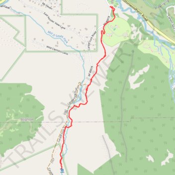
Interactive trail map
Trail profile
- Distance: 4.8 Km
- Elevation gain: 182 m
- Maximum elevation: 2,403 m
- Elevation loss: 182 m
- Minimum elevation: 2,228 m
- Moving time: 1 h 24 m
- Moving speed: 3.4 Km/h
- Maximum speed: 8.8 Km/h
- Total time: 1 h 42 m
- Global speed: 2.8 Km/h
About this trail
Name: Donut Falls trail, distance, elevation, map, profile, GPS track
Start: Cardiff Fork Road, Pine Lodge, Brighton, Salt Lake County, Utah, United States (40.64756 -111.64808)
End: Cardiff Fork Road, Pine Lodge, Brighton, Salt Lake County, Utah, United States (40.64757 -111.64807)
Coordinates: 40.63113 -111.65474 40.64758 -111.64741
Other hiking, mountain biking, running and outdoor activity trails
Click on a trail to view its statistics, map and profile.
Donut Falls Trail in Uinta-Wasatch-Cache National Forest
United States > Utah > Salt Lake County > Brighton
Donut Falls Trail, located in the Uinta-Wasatch-Cache National Forest, offers a picturesque and moderately challenging hiking experience. The trail leads hikers through dense forests of pine and aspen, where the tranquil sounds of nature accompany you on your journey. The trail culminates at the unique Donut…
Distance: 5.2 Km • Elevation gain: 190 m • Maximum elevation: 2,394 m