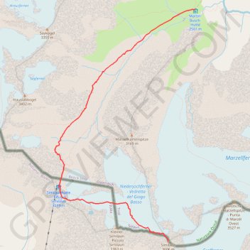
Similaun-MartinBuschHuette
- Distance: 14.9 Km
- Elevation gain: 1,113 m
- Maximum elevation: 3,573 m
- Elevation loss: 1,113 m
- Minimum elevation: 2,498 m
Interactive trail map
Trail profile
- Distance: 14.9 Km
- Elevation gain: 1,113 m
- Maximum elevation: 3,573 m
- Elevation loss: 1,113 m
- Minimum elevation: 2,498 m
About this trail
Name: Similaun-MartinBuschHuette trail, distance, elevation, map, profile, GPS track
Start: Martin-Busch-Hütte, 403, Hütten Vent, Sölden, Bezirk Imst, Tyrol, 6458, Austria (46.80128 10.88711)
End: Martin-Busch-Hütte, 403, Hütten Vent, Sölden, Bezirk Imst, Tyrol, 6458, Austria (46.80128 10.88711)
Coordinates: 46.76372 10.85379 46.80128 10.88711