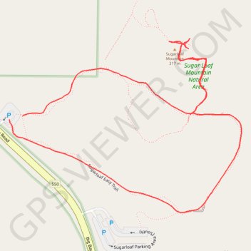
Sugarloaf Mountain Loop Trail in Sugarloaf Mountain Natural Area
The Sugarloaf Mountain Loop Trail provides a rewarding hike through a lush forest canopy. As you ascend, you will encounter impressive rock outcroppings and an evolving landscape that transitions into wooden stairs as you near the summit. At the top, the panoramic views encompass the vastness of Lake Superior, the surrounding forested terrain, and the distinctive landmarks of Marquette, including the Superior Dome and Presque Isle Park. This loop is a great option for those seeking a moderate, scenic hike with a sense of both tranquility and awe-inspiring vistas. #Hiking #Loop #Mountain #Lake #Forest #Nature
- Distance: 1.8 Km
- Elevation gain: 81 m
- Maximum elevation: 310 m
- Elevation loss: 83 m
- Minimum elevation: 230 m
- Moving time: 24 m 33 s
- Moving speed: 4.4 Km/h
- Maximum speed: 8.9 Km/h
- Total time: 28 m 28 s
- Global speed: 3.8 Km/h
Interactive trail map
Trail profile
- Distance: 1.8 Km
- Elevation gain: 81 m
- Maximum elevation: 310 m
- Elevation loss: 83 m
- Minimum elevation: 230 m
- Moving time: 24 m 33 s
- Moving speed: 4.4 Km/h
- Maximum speed: 8.9 Km/h
- Total time: 28 m 28 s
- Global speed: 3.8 Km/h
About this trail
Name: Sugarloaf Mountain Loop Trail in Sugarloaf Mountain Natural Area trail, distance, elevation, map, profile, GPS track
Coordinates: 46.60134 -87.45989 46.60458 -87.45360