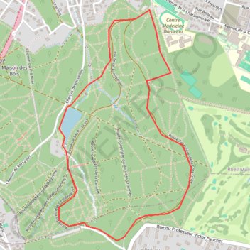
Le tour de Saint cucufa
https://en-gb.gps-viewer.com/track-lwkzs/Le-tour-de-Saint-cucufa/
- Distance: 4.3 Km
- Elevation gain: 73 m
- Maximum elevation: 167 m
- Elevation loss: 73 m
- Minimum elevation: 108 m
Interactive trail map
Trail profile
- Distance: 4.3 Km
- Elevation gain: 73 m
- Maximum elevation: 167 m
- Elevation loss: 73 m
- Minimum elevation: 108 m
About this trail
Name: Le tour de Saint cucufa trail, distance, elevation, map, profile, GPS track
Coordinates: 48.84768 2.16296 48.86127 2.17479
Other hiking, mountain biking, running and outdoor activity trails
Click on a trail to view its statistics, map and profile.
GR22-1-1 De Paris au Mont-Saint-Michel, Paris - Versailles
France > Ile-de-France > Paris
Distance: 30.9 Km • Elevation gain: 470 m • Maximum elevation: 182 m
Paris - Mantes-la-Jolie
France > Ile-de-France > Hauts-de-Seine > Boulogne-Billancourt > Jardin de la Mairie
Distance: 51.9 Km • Elevation gain: 524 m • Maximum elevation: 186 m