Import a GPX file

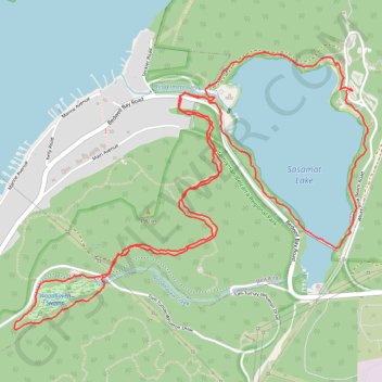
Sasamat Lake - Woodhaven Swamp

Belcarra Regional Park. #Hiking #Loop #Belcarra

  • Distance: 8.9 Km
  • Elevation gain: 275 m
  • Maximum elevation: 150 m
  • Elevation loss: 275 m
  • Minimum elevation: 47 m

Interactive trail map

Trail profile

  • Distance: 8.9 Km
  • Elevation gain: 275 m
  • Maximum elevation: 150 m
  • Elevation loss: 275 m
  • Minimum elevation: 47 m

About this trail

Other hiking, mountain biking, running and outdoor activity trails

Click on a trail to view its statistics, map and profile.

Vancouver - Golden

Canada > British Columbia > Metro Vancouver Regional District > Vancouver

#Bike #Vancouver #Golden

Distance: 827.6 Km • Elevation gain: 9,376 m • Maximum elevation: 1,347 m

Gear up for your next adventure:

🏃Compression Recovery Socks - Reduce leg fatigue after heavy days of elevation gain
🔭Compact Hiking Binoculars - Lightweight optics for scouting routes or birdwatching
🧼Biodegradable Soap - Eco-friendly outdoor soap
📕Australia Maps - Maps covering Australian regions
🧦Hiking Socks - Comfortable socks for long hikes

As an Amazon Associate, this site earns from qualifying purchases at no extra cost to you.