Import a GPX file

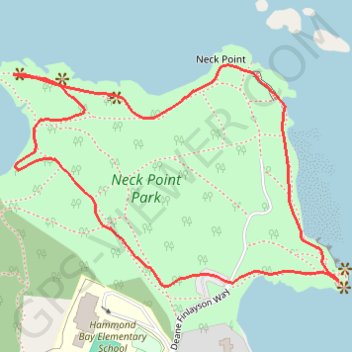
Neck Point Park Loop

Neck Point Park. Vancouver Island. #Hiking #Loop #NeckPoint #Vancouver

  • Distance: 1.7 Km
  • Elevation gain: 35 m
  • Maximum elevation: 20 m
  • Elevation loss: 35 m
  • Minimum elevation: 0 m

Interactive trail map

Trail profile

  • Distance: 1.7 Km
  • Elevation gain: 35 m
  • Maximum elevation: 20 m
  • Elevation loss: 35 m
  • Minimum elevation: 0 m

About this trail

Gear up for your next adventure:

🪫Rechargeable Headlamps - USB rechargeable headlamps
🚴Bike GPS - GPS devices for cycling
🔥Windproof Plasma Lighters - USB rechargeable lighters that work in high-altitude winds
Outdoor Coffee Makers - Enjoy quality coffee at the summit of your favorite peak
👣Snake & Scrub Gaiters - Protection against spinifex, mud, and snakes while walking off-track

As an Amazon Associate, this site earns from qualifying purchases at no extra cost to you.