Thank you for supporting this site ❤️
Make a donation
Make a donation
Gear up for your next adventure:
As an Amazon Associate, this site earns from qualifying purchases at no extra cost to you.
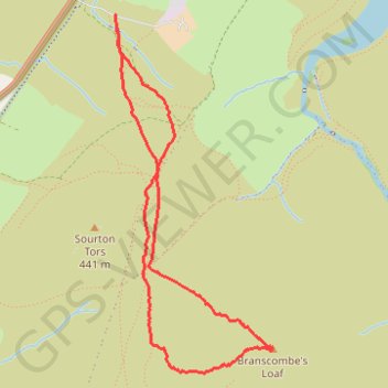
Branscombe Loaf
- Distance: 5.4 Km
- Elevation gain: 242 m
- Maximum elevation: 535 m
- Elevation loss: 244 m
- Minimum elevation: 290 m
- Moving time: 1 h 33 m
- Moving speed: 3.5 Km/h
- Maximum speed: 6.3 Km/h
- Total time: 1 h 55 m
- Global speed: 2.8 Km/h
Interactive trail map
Thank you for supporting this site ❤️
Make a donation
Make a donation
Gear up for your next adventure:
As an Amazon Associate, this site earns from qualifying purchases at no extra cost to you.
Trail profile
- Distance: 5.4 Km
- Elevation gain: 242 m
- Maximum elevation: 535 m
- Elevation loss: 244 m
- Minimum elevation: 290 m
- Moving time: 1 h 33 m
- Moving speed: 3.5 Km/h
- Maximum speed: 6.3 Km/h
- Total time: 1 h 55 m
- Global speed: 2.8 Km/h
Thank you for supporting this site ❤️
Make a donation
Make a donation
Gear up for your next adventure:
As an Amazon Associate, this site earns from qualifying purchases at no extra cost to you.
About this trail
Name: Branscombe Loaf trail, distance, elevation, map, profile, GPS track
Coordinates: 50.68247 -4.06216 50.70062 -4.04953
Thank you for supporting this site ❤️
Make a donation
Make a donation
Gear up for your next adventure:
As an Amazon Associate, this site earns from qualifying purchases at no extra cost to you.