Thank you for supporting this site ❤️
Make a donation
Make a donation
Gear up for your next adventure:
As an Amazon Associate, this site earns from qualifying purchases at no extra cost to you.
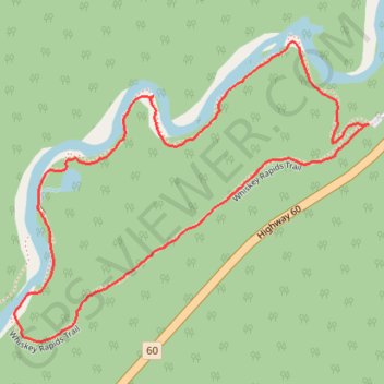
Algonquin Whiskey Rapids loop trail
- Distance: 2.1 Km
- Elevation gain: 32 m
- Maximum elevation: 439 m
- Elevation loss: 32 m
- Minimum elevation: 411 m
- Moving time: 44 m 14 s
- Moving speed: 2.9 Km/h
- Maximum speed: 6.0 Km/h
- Total time: 1 h 4 m
- Global speed: 2.0 Km/h
Interactive trail map
Thank you for supporting this site ❤️
Make a donation
Make a donation
Gear up for your next adventure:
As an Amazon Associate, this site earns from qualifying purchases at no extra cost to you.
Trail profile
- Distance: 2.1 Km
- Elevation gain: 32 m
- Maximum elevation: 439 m
- Elevation loss: 32 m
- Minimum elevation: 411 m
- Moving time: 44 m 14 s
- Moving speed: 2.9 Km/h
- Maximum speed: 6.0 Km/h
- Total time: 1 h 4 m
- Global speed: 2.0 Km/h
Thank you for supporting this site ❤️
Make a donation
Make a donation
Gear up for your next adventure:
As an Amazon Associate, this site earns from qualifying purchases at no extra cost to you.
About this trail
Name: Algonquin Whiskey Rapids loop trail trail, distance, elevation, map, profile, GPS track
Coordinates: 45.48173 -78.76473 45.48657 -78.75656
Thank you for supporting this site ❤️
Make a donation
Make a donation
Gear up for your next adventure:
As an Amazon Associate, this site earns from qualifying purchases at no extra cost to you.
Other hiking, mountain biking, running and outdoor activity trails
Click on a trail to view its statistics, map and profile.