Thank you for supporting this site ❤️
Make a donation
Make a donation
Gear up for your next adventure:
As an Amazon Associate, this site earns from qualifying purchases at no extra cost to you.
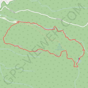
Loop walk in Main Range National Park
Goomburra Walking
- Distance: 8.3 Km
- Elevation gain: 328 m
- Maximum elevation: 1,008 m
- Elevation loss: 328 m
- Minimum elevation: 704 m
- Moving time: 3 h 16 m
- Moving speed: 2.5 Km/h
- Maximum speed: 10.2 Km/h
- Total time: 4 h 31 m
- Global speed: 1.8 Km/h
Interactive trail map
Thank you for supporting this site ❤️
Make a donation
Make a donation
Gear up for your next adventure:
As an Amazon Associate, this site earns from qualifying purchases at no extra cost to you.
Trail profile
- Distance: 8.3 Km
- Elevation gain: 328 m
- Maximum elevation: 1,008 m
- Elevation loss: 328 m
- Minimum elevation: 704 m
- Moving time: 3 h 16 m
- Moving speed: 2.5 Km/h
- Maximum speed: 10.2 Km/h
- Total time: 4 h 31 m
- Global speed: 1.8 Km/h
Thank you for supporting this site ❤️
Make a donation
Make a donation
Gear up for your next adventure:
As an Amazon Associate, this site earns from qualifying purchases at no extra cost to you.
About this trail
Name: Loop walk in Main Range National Park trail, distance, elevation, map, profile, GPS track
Coordinates: -27.99352 152.34321 -27.98056 152.36915
Topography: Queensland topographic map, elevation, terrain
Thank you for supporting this site ❤️
Make a donation
Make a donation
Gear up for your next adventure:
As an Amazon Associate, this site earns from qualifying purchases at no extra cost to you.