Paliza Canyon in Jemez Ponderosa area
Exploring another Jemez area.
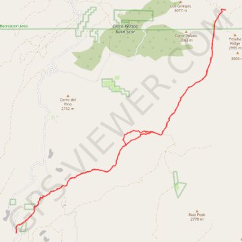
- Distance: 31.2 Km
- Elevation gain: 913 m
- Maximum elevation: 2,882 m
- Elevation loss: 913 m
- Minimum elevation: 2,090 m
- Moving time: 3 h 49 m
- Moving speed: 8.1 Km/h
- Maximum speed: 34.9 Km/h
- Total time: 4 h 16 m
- Global speed: 7.3 Km/h
Interactive trail map
Trail profile
- Distance: 31.2 Km
- Elevation gain: 913 m
- Maximum elevation: 2,882 m
- Elevation loss: 913 m
- Minimum elevation: 2,090 m
- Moving time: 3 h 49 m
- Moving speed: 8.1 Km/h
- Maximum speed: 34.9 Km/h
- Total time: 4 h 16 m
- Global speed: 7.3 Km/h
About this trail
Name: Paliza Canyon in Jemez Ponderosa area trail, distance, elevation, map, profile, GPS track
Start: NM 290, Sandoval County, New Mexico, 87044, United States (35.70891 -106.62738)
End: NM 290, Sandoval County, New Mexico, 87044, United States (35.70889 -106.62740)
Coordinates: 35.70889 -106.62744 35.79259 -106.53064