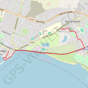
Saltcoats, Scotland to Stevenston
Afternoon Walk
- Distance: 3.8 Km
- Elevation gain: 18 m
- Maximum elevation: 8 m
- Elevation loss: 18 m
- Minimum elevation: 0 m
- Moving time: 47 m 11 s
- Moving speed: 4.9 Km/h
- Maximum speed: 7.4 Km/h
- Total time: 1 h 4 m
- Global speed: 3.6 Km/h
Interactive trail map
Trail profile
- Distance: 3.8 Km
- Elevation gain: 18 m
- Maximum elevation: 8 m
- Elevation loss: 18 m
- Minimum elevation: 0 m
- Moving time: 47 m 11 s
- Moving speed: 4.9 Km/h
- Maximum speed: 7.4 Km/h
- Total time: 1 h 4 m
- Global speed: 3.6 Km/h
About this trail
Name: Saltcoats, Scotland to Stevenston trail, distance, elevation, map, profile, GPS track
Start: Countess Street, Saltcoats, North Ayrshire, Scotland, KA21 5HP, United Kingdom (55.63310 -4.78497)
Coordinates: 55.63087 -4.78740 55.63897 -4.75135
Other hiking, mountain biking, running and outdoor activity trails
Click on a trail to view its statistics, map and profile.
Irvine, Scotland to Stevenston and back
United Kingdom > Scotland > North Ayrshire > Irvine
Morning Bike Ride
Distance: 18.9 Km • Elevation gain: 69 m • Maximum elevation: 28 m
Irvine, Scotland to Largs and back
United Kingdom > Scotland > North Ayrshire > Irvine
Morning Bike Ride
Distance: 66.9 Km • Elevation gain: 324 m • Maximum elevation: 35 m
Irvine, Scotland to West Kilbride and back
United Kingdom > Scotland > North Ayrshire > Irvine
Afternoon Bike Ride
Distance: 40.2 Km • Elevation gain: 283 m • Maximum elevation: 101 m
Irvine, Scotland to Stevenston and back
United Kingdom > Scotland > North Ayrshire > Irvine
Afternoon Bike Ride
Distance: 18.8 Km • Elevation gain: 71 m • Maximum elevation: 28 m
Irvine, Scotland to Stevenston and back
United Kingdom > Scotland > North Ayrshire > Irvine
Evening Bike Ride
Distance: 18.6 Km • Elevation gain: 66 m • Maximum elevation: 22 m
Irvine, Scotland to Stevenston and back
United Kingdom > Scotland > North Ayrshire > Irvine
Morning Bike Ride
Distance: 19.0 Km • Elevation gain: 75 m • Maximum elevation: 29 m
Irvine, Scotland to Saltcoats and back
United Kingdom > Scotland > North Ayrshire > Irvine
Afternoon Bike Ride
Distance: 22.4 Km • Elevation gain: 81 m • Maximum elevation: 22 m
Irvine, Scotland to Stevenston and back
United Kingdom > Scotland > North Ayrshire > Irvine
Bike
Distance: 21.4 Km • Elevation gain: 88 m • Maximum elevation: 28 m
Irvine, Scotland to Stevenston and back
United Kingdom > Scotland > North Ayrshire > Irvine
Bike
Distance: 18.3 Km • Elevation gain: 67 m • Maximum elevation: 22 m
Irvine, Scotland to Stevenston and back
United Kingdom > Scotland > North Ayrshire > Irvine
Bike
Distance: 18.4 Km • Elevation gain: 65 m • Maximum elevation: 28 m
Irvine, Scotland to Stevenston and back
United Kingdom > Scotland > North Ayrshire > Irvine
Bike
Distance: 17.2 Km • Elevation gain: 49 m • Maximum elevation: 13 m
Irvine, Scotland to Ardrossan and back
United Kingdom > Scotland > North Ayrshire > Irvine
Bike
Distance: 31.2 Km • Elevation gain: 115 m • Maximum elevation: 22 m
Irvine, Scotland to Fairlie and back
United Kingdom > Scotland > North Ayrshire > Irvine
Bike
Distance: 51.8 Km • Elevation gain: 519 m • Maximum elevation: 252 m