Brandwood Road, Canal, Lindsworth Park
- Distance: 6.0 Km
- Elevation gain: 53 m
- Maximum elevation: 169 m
- Elevation loss: 53 m
- Minimum elevation: 132 m
- Moving time: 29 m 22 s
- Moving speed: 12.2 Km/h
- Maximum speed: 48.4 Km/h
- Total time: 29 m 22 s
- Global speed: 12.2 Km/h
Interactive trail map
Trail profile
- Distance: 6.0 Km
- Elevation gain: 53 m
- Maximum elevation: 169 m
- Elevation loss: 53 m
- Minimum elevation: 132 m
- Moving time: 29 m 22 s
- Moving speed: 12.2 Km/h
- Maximum speed: 48.4 Km/h
- Total time: 29 m 22 s
- Global speed: 12.2 Km/h
About this trail
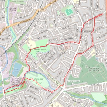
Name: Brandwood Road, Canal, Lindsworth Park trail, distance, elevation, map, profile, GPS track
Coordinates: 52.41291 -1.91933 52.42558 -1.89355
Other hiking, mountain biking, running and outdoor activity trails
Click on a trail to view its statistics, map and profile.
Loop trail through Highbury Park and along the River Rea
United Kingdom > England > Birmingham > Brandwood End
Distance: 10.3 Km • Elevation gain: 99 m • Maximum elevation: 164 m
The other side of the canal
United Kingdom > England > Birmingham > Brandwood End
Distance: 8.3 Km • Elevation gain: 72 m • Maximum elevation: 169 m
Lindsworth Park / Canal
United Kingdom > England > Birmingham > Brandwood End
Distance: 6.0 Km • Elevation gain: 54 m • Maximum elevation: 170 m
Chinn Brook run
United Kingdom > England > Birmingham > Brandwood End
Distance: 9.9 Km • Elevation gain: 71 m • Maximum elevation: 169 m