Thank you for supporting this site ❤️
Make a donation
Make a donation
Gear up for your next adventure:
As an Amazon Associate, this site earns from qualifying purchases at no extra cost to you.
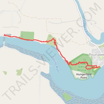
Pounawea Bush Walk via Hinahina Track
- Distance: 6.5 Km
- Elevation gain: 100 m
- Maximum elevation: 32 m
- Elevation loss: 100 m
- Minimum elevation: 1 m
- Moving time: 1 h 24 m
- Moving speed: 4.6 Km/h
- Maximum speed: 7.3 Km/h
- Total time: 1 h 46 m
- Global speed: 3.7 Km/h
Interactive trail map
Thank you for supporting this site ❤️
Make a donation
Make a donation
Gear up for your next adventure:
As an Amazon Associate, this site earns from qualifying purchases at no extra cost to you.
Trail profile
- Distance: 6.5 Km
- Elevation gain: 100 m
- Maximum elevation: 32 m
- Elevation loss: 100 m
- Minimum elevation: 1 m
- Moving time: 1 h 24 m
- Moving speed: 4.6 Km/h
- Maximum speed: 7.3 Km/h
- Total time: 1 h 46 m
- Global speed: 3.7 Km/h
Thank you for supporting this site ❤️
Make a donation
Make a donation
Gear up for your next adventure:
As an Amazon Associate, this site earns from qualifying purchases at no extra cost to you.
About this trail
Name: Pounawea Bush Walk via Hinahina Track trail, distance, elevation, map, profile, GPS track
Start: 1, Park Lane, Pounawea, Clutha District, Otago, 9535, New Zealand (-46.47588 169.69387)
End: Park Lane, Pounawea, Clutha District, Otago, 9535, New Zealand (-46.47589 169.69377)
Coordinates: -46.47641 169.66372 -46.46899 169.69387
Thank you for supporting this site ❤️
Make a donation
Make a donation
Gear up for your next adventure:
🧊Insulated Stainless Steel Flasks - Keep water cold for 24 hours in the heat or coffee hot in the cold
⌚Altimeter Barometer Watches - Outdoor watches with built-in sensors to track altitude changes and weather shifts
As an Amazon Associate, this site earns from qualifying purchases at no extra cost to you.
Other hiking, mountain biking, running and outdoor activity trails
Click on a trail to view its statistics, map and profile.