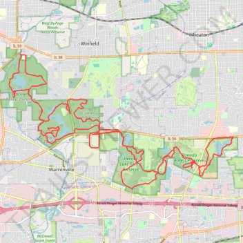
Gravel bike loop
Danada Forest Preserve, Rice Lake, Herrick Lake Forest Preserve, St. James Farm Preserve, Silver Lake, Mount Hoy, Blackwell Forest Preserve, McKee Marsh.
- Distance: 47.0 Km
- Elevation gain: 261 m
- Maximum elevation: 249 m
- Elevation loss: 261 m
- Minimum elevation: 212 m
- Moving time: 2 h 17 m
- Moving speed: 20.5 Km/h
- Maximum speed: 45.7 Km/h
- Total time: 2 h 24 m
- Global speed: 19.5 Km/h
Interactive trail map
Trail profile
- Distance: 47.0 Km
- Elevation gain: 261 m
- Maximum elevation: 249 m
- Elevation loss: 261 m
- Minimum elevation: 212 m
- Moving time: 2 h 17 m
- Moving speed: 20.5 Km/h
- Maximum speed: 45.7 Km/h
- Total time: 2 h 24 m
- Global speed: 19.5 Km/h
About this trail
Name: Gravel bike loop trail, distance, elevation, map, profile, GPS track
Start: Frank H. Bellinger Parkway, DuPage County, Illinois, 60189, United States (41.81845 -88.11321)
End: Frank H. Bellinger Parkway, DuPage County, Illinois, 60189, United States (41.81843 -88.11319)
Coordinates: 41.81102 -88.19838 41.85805 -88.09376