Make a donation
Gear up for your next adventure:
As an Amazon Associate, this site earns from qualifying purchases at no extra cost to you.
The Port
- Distance: 37.9 Km
- Elevation gain: 191 m
- Maximum elevation: 71 m
- Elevation loss: 191 m
- Minimum elevation: 3 m
Interactive trail map
Make a donation
Gear up for your next adventure:
As an Amazon Associate, this site earns from qualifying purchases at no extra cost to you.
Trail profile
- Distance: 37.9 Km
- Elevation gain: 191 m
- Maximum elevation: 71 m
- Elevation loss: 191 m
- Minimum elevation: 3 m
Make a donation
Gear up for your next adventure:
As an Amazon Associate, this site earns from qualifying purchases at no extra cost to you.
About this trail
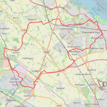
Name: The Port trail, distance, elevation, map, profile, GPS track
Start: Weighbridge Road, Connah's Quay, Flintshire, Wales, CH5 2TW, United Kingdom (53.24353 -3.03054)
End: Weighbridge Road, Connah's Quay, Flintshire, Wales, CH5 2TW, United Kingdom (53.24338 -3.03043)
Coordinates: 53.22258 -3.04919 53.29261 -2.88237
Make a donation
Gear up for your next adventure:
As an Amazon Associate, this site earns from qualifying purchases at no extra cost to you.
Other hiking, mountain biking, running and outdoor activity trails
Click on a trail to view its statistics, map and profile.
Bike Loop from Chester
United Kingdom > England > Cheshire West and Chester > Chester
#Bike #Loop #Road #Countryside #Nature
Distance: 82.8 Km • Elevation gain: 532 m • Maximum elevation: 163 m